


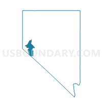
Precinct No. 12-SOUTH DAYTON #4, Lyon County, Nevada
About
Outline

Summary
| Unique Area Identifier | 615397 |
| Name | Precinct No. 12-SOUTH DAYTON #4 |
| County | Lyon County |
| State | Nevada |
| Area (square miles) | 166.26 |
| Land Area (square miles) | 166.20 |
| Water Area (square miles) | 0.07 |
| % of Land Area | 99.96 |
| % of Water Area | 0.04 |
| Latitude of the Internal Point | 39.19287000 |
| Longtitude of the Internal Point | -119.44545180 |
Maps


Graphs
Select a template below for downloading or customizing gragh for Precinct No. 12-SOUTH DAYTON #4, Lyon County, Nevada


Neighbors
Neighoring Voting District (by Name) Neighboring Voting District on the Map
- Precinct 14 - Pinenut, Douglas County, NV
- Precinct 311, Carson City, NV
- Precinct No. 10-SOUTH DAYTON #2, Lyon County, NV
- Precinct No. 11-SOUTH DAYTON #3, Lyon County, NV
- Precinct No. 16-NORTH DAYTON #4, Lyon County, NV
- Precinct No. 17-NORTH DAYTON #5, Lyon County, NV
- Precinct No. 19-MOUND HOUSE #2, Lyon County, NV
- Precinct No. 22-STAGECOACH #2, Lyon County, NV
- Precinct No. 4-WEST MASON VALLEY #2, Lyon County, NV
- Precinct No. 9-SOUTH DAYTON #1, Lyon County, NV
Top 10 Neighboring County Subdivision (by Population) Neighboring County Subdivision on the Map
- Carson City CCD, Carson City, NV (55,274)
- Gardnerville-Minden CCD, Douglas County, NV (30,220)
- Dayton CCD, Lyon County, NV (15,276)
- Yerington CCD, Lyon County, NV (7,886)
- Silver Springs CCD, Lyon County, NV (7,629)
- Pine Nut CCD, Douglas County, NV (958)
Top 10 Neighboring Place (by Population) Neighboring Place on the Map
Top 10 Neighboring Unified School District (by Population) Neighboring Unified School District on the Map
- Carson City School District, NV (55,274)
- Lyon County School District, NV (51,980)
- Douglas County School District, NV (46,997)
Top 10 Neighboring State Legislative District Lower Chamber (by Population) Neighboring State Legislative District Lower Chamber on the Map
Top 10 Neighboring State Legislative District Upper Chamber (by Population) Neighboring State Legislative District Upper Chamber on the Map
Top 10 Neighboring 111th Congressional District (by Population) Neighboring 111th Congressional District on the Map
Top 10 Neighboring Census Tract (by Population) Neighboring Census Tract on the Map
- Census Tract 9603.02, Lyon County, NV (9,521)
- Census Tract 9609, Lyon County, NV (5,468)
- Census Tract 9602.01, Lyon County, NV (4,221)
- Census Tract 9603.03, Lyon County, NV (3,986)
- Census Tract 10.02, Carson City, NV (3,757)
- Census Tract 23, Douglas County, NV (3,615)
- Census Tract 9603.01, Lyon County, NV (1,769)